


Spring Lake Twp. Voting District, Scott County, Minnesota
About
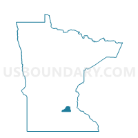
Outline

Summary
| Unique Area Identifier | 604340 |
| Name | Spring Lake Twp. Voting District |
| County | Scott County |
| State | Minnesota |
| Area (square miles) | 29.75 |
| Land Area (square miles) | 28.18 |
| Water Area (square miles) | 1.57 |
| % of Land Area | 94.74 |
| % of Water Area | 5.26 |
| Latitude of the Internal Point | 44.66812360 |
| Longtitude of the Internal Point | -93.46323210 |
Maps


Graphs
Select a template below for downloading or customizing gragh for Spring Lake Twp. Voting District, Scott County, Minnesota


Neighbors
Neighoring Voting District (by Name) Neighboring Voting District on the Map
- Cedar Lake Twp. Voting District, Scott County, MN
- Credit River Twp. Voting District, Scott County, MN
- Helena Twp. Voting District, Scott County, MN
- Louisville Twp. Voting District, Scott County, MN
- New Market Twp. Voting District, Scott County, MN
- Prior Lake P-3, Scott County, MN
- Prior Lake P-4, Scott County, MN
- Prior Lake P-7, Scott County, MN
- Sand Creek Twp. Voting District, Scott County, MN
- Shakopee P-7, Scott County, MN
Top 10 Neighboring County Subdivision (by Population) Neighboring County Subdivision on the Map
- Shakopee city, Scott County, MN (37,076)
- Prior Lake city, Scott County, MN (22,796)
- Credit River township, Scott County, MN (5,096)
- Spring Lake township, Scott County, MN (3,631)
- New Market township, Scott County, MN (3,440)
- Cedar Lake township, Scott County, MN (2,779)
- Helena township, Scott County, MN (1,648)
- Sand Creek township, Scott County, MN (1,521)
- Louisville township, Scott County, MN (1,266)
Top 10 Neighboring Place (by Population) Neighboring Place on the Map
Top 10 Neighboring Unified School District (by Population) Neighboring Unified School District on the Map
- Lakeville Public School District, MN (51,397)
- Shakopee Public School District, MN (42,411)
- Prior Lake-Savage Area Schools, MN (36,761)
- Jordan Public School District, MN (8,983)
Top 10 Neighboring State Legislative District Lower Chamber (by Population) Neighboring State Legislative District Lower Chamber on the Map
- State House District 35A, MN (59,872)
- State House District 35B, MN (48,692)
- State House District 34A, MN (47,533)
- State House District 25B, MN (45,574)
Top 10 Neighboring State Legislative District Upper Chamber (by Population) Neighboring State Legislative District Upper Chamber on the Map
- State Senate District 35, MN (108,564)
- State Senate District 34, MN (94,255)
- State Senate District 25, MN (85,965)
Top 10 Neighboring 111th Congressional District (by Population) Neighboring 111th Congressional District on the Map
Top 10 Neighboring Census Tract (by Population) Neighboring Census Tract on the Map
- Census Tract 803.02, Scott County, MN (14,633)
- Census Tract 811, Scott County, MN (10,329)
- Census Tract 808, Scott County, MN (7,720)
- Census Tract 810, Scott County, MN (7,580)
- Census Tract 809.04, Scott County, MN (7,381)
- Census Tract 809.03, Scott County, MN (6,756)
- Census Tract 812, Scott County, MN (5,928)